 Menu
Menu dominican map punta cana
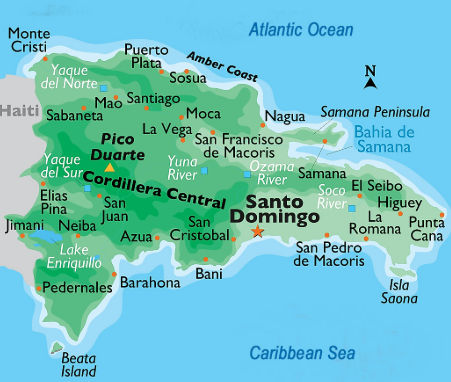
Discover the essential locations and routes with a comprehensive dominican map punta cana. Learn about resort areas, pristine beaches, and the benefits of booking reliable private transportation for your Caribbean vacation.
Understanding the Geography with a Dominican Map Punta Cana
Arriving in the Caribbean for a tropical vacation is an exciting experience, and familiarizing yourself with the local geography is the first step to ensuring a seamless trip. When you look at a dominican map punta cana, you will immediately notice that this world-renowned destination is located on the easternmost tip of the country, in the La Altagracia province. This specific geographic positioning is what gives the region its spectacular sunrise views and endless stretches of white sand beaches meeting the turquoise waters of the Atlantic Ocean and the Caribbean Sea.
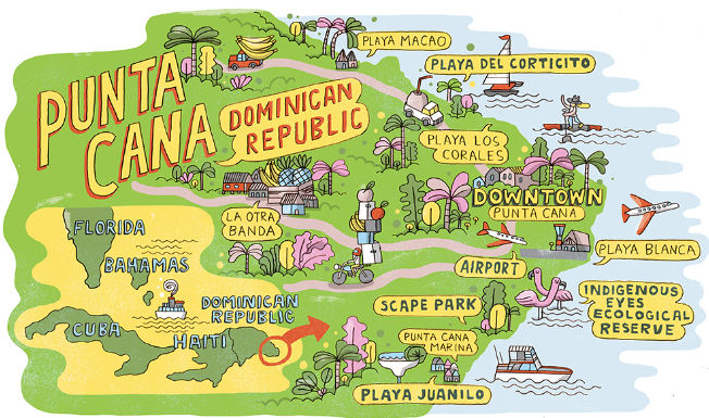
The layout of the area is spread out along the coastline, meaning that distances between the airport, your resort, and various attractions can be significant. By studying a dominican map punta cana before your arrival, you can visualize the different zones, calculate travel times, and make informed decisions about your itinerary. Understanding these distances is crucial for planning your transfers, which is why securing reliable private transportation is highly recommended to navigate the region comfortably and efficiently.
Navigating from Punta Cana International Airport
The central hub for almost all international arrivals in this region is the Punta Cana International Airport (PUJ). On any standard dominican map punta cana, you will find the airport conveniently located in the southern part of the main tourist corridor. While the airport is relatively close to some accommodations, the main resort areas stretch far to the north along the coastline.
The Importance of Pre-Booking Private Transportation
Once you clear customs and step out of the terminal, the tropical heat and bustling crowds can be overwhelming. This is where pre-arranged private transportation becomes an invaluable asset for your vacation. Unlike shared shuttles that make dozens of stops at various hotels, a private transfer offers a direct route to your destination. Your professional driver will know the exact location of your resort on the dominican map punta cana, ensuring you travel via the most efficient highways, such as the Boulevard Turistico del Este. With a private vehicle, you enjoy air conditioning, immediate departure, and the peace of mind that comes with traveling exclusively with your own party.
Key Resort Areas to Locate on the Coastline
The coastline is divided into several distinct neighborhoods and beachfronts, each offering a unique atmosphere and catering to different types of travelers. Knowing where these are located on your dominican map punta cana will help you choose the right accommodation and plan your daily activities.
Cap Cana: Luxury and Exclusivity
Located just south of the international airport, Cap Cana is an exclusive, gated community known for its high-end luxury resorts, a spectacular marina, and the famous Punta Espada Golf Course. Because it is physically separated from the main bustling areas to the north, traveling in and out of Cap Cana is best done via private transport, allowing you seamless access through the security gates.
Bavaro: The Heart of the Action
Moving north on the dominican map punta cana, you will find Bavaro. This is the most developed and vibrant section of the coastline. Bavaro is famous for its exceptionally wide, palm-fringed beaches, bustling nightlife, diverse restaurants, and numerous shopping plazas. Because Bavaro is expansive, getting from one end to the other requires motorized transport. Private transfers make evening outings to local restaurants or entertainment venues safe and effortless.
Macao and Uvero Alto: Secluded Tranquility
Further north along the coast lie the areas of Macao and Uvero Alto. These zones are characterized by their more dramatic waves, lush surroundings, and secluded, tranquil resorts. Looking at your dominican map punta cana, you will see that Uvero Alto is the furthest resort area from the airport, often taking 45 minutes to an hour to reach. For this journey, private transportation is highly advised to avoid the lengthy travel times associated with shared buses that stop at multiple resorts in Bavaro before finally heading north.
Exploring Beyond the Immediate Resort Zones
While the beaches are the main draw, the Dominican Republic has a rich landscape waiting to be explored. A comprehensive dominican map punta cana will also show the connecting highways that lead to spectacular day-trip destinations. The Autopista del Coral is a modern highway that quickly connects the eastern tip to destinations like Bayahibe, where catamarans depart for Saona Island, or even the historic capital city of Santo Domingo.
Booking a private driver for these longer excursions allows you to customize your schedule, stop for photos along the scenic routes, and travel in superior comfort. You control the pace of your day, making your exploration of the island entirely personalized and stress-free.
Enhancing Your Travel Experience
Ultimately, a successful vacation is about minimizing stress and maximizing relaxation. By familiarizing yourself with a dominican map punta cana, you set realistic expectations for travel times between the airport, your hotel, and top attractions. Pairing this geographical knowledge with the luxury and convenience of private transportation ensures that every moment of your trip is spent enjoying the beauty of the Caribbean, rather than worrying about logistics, navigating unfamiliar roads, or waiting in long lines for taxis.
Frequently Asked Questions (FAQ)
- How far is Uvero Alto from the Punta Cana International Airport?
On the dominican map punta cana, Uvero Alto is located at the northernmost end of the main tourist strip. It is approximately 40 to 45 kilometers from the airport, and the drive typically takes about 45 to 60 minutes when utilizing direct private transportation. - Why is private transportation recommended over shared shuttles?
Private transportation offers a direct, non-stop route from the airport to your specific resort. Shared shuttles often involve waiting for other passengers to arrive and making numerous drop-offs along the coast, which can add hours to your travel time depending on your resort's location on the map. - Are there major highways connecting the airport to the resort areas?
Yes, the primary route used by private transfer services is the Boulevard Turistico del Este. This well-maintained highway bypasses local city traffic, allowing for smooth and rapid transit to the various beachfront communities like Bavaro, Macao, and Uvero Alto. - Can I easily travel between different resort zones like Cap Cana and Bavaro?
While they appear close on a dominican map punta cana, walking between these zones is not feasible due to the distances and lack of pedestrian paths along the highways. The safest and most efficient way to travel between different sectors for dinner or activities is by booking a private transfer.