 Menu
Menu Punta Cana Map
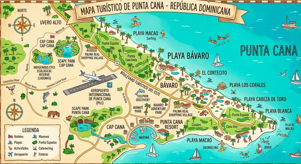
Explore the different areas, beaches, and distances from the airport with this detailed article about the Punta Cana map, ideal for planning your transfers and vacations.
Understanding The Geography With A Punta Cana Map
When planning a vacation on the east coast of the Dominican Republic, having a clear vision of the territorial layout is a vital factor to maximize your time. Detailly analyzing a Punta Cana map allows you to precisely locate your resort, nearby attractions, and, most importantly, the transportation routes from the airport to your final destination. This region is extensive and is made up of several micro-destinations, each with its own charm, level of exclusivity, and distance from the main access roads.
Many people assume that the entire coastal strip is identical, but the geographical reality shows that there are significant differences in transfer times and mobility logistics. Using professional private transportation services, such as those we offer at Taxi Dominicana, ensures you reach any point you visualize on your map quickly, comfortably, and without the common setbacks of shared routes.
Main Areas Highlighted On The Map
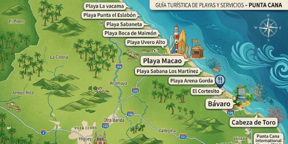
The tourist strip extends for dozens of kilometers along the coast, spanning from the exclusive areas of the south to the remote and tranquil beaches of the north. Knowing the exact location of these areas will help you effectively coordinate your transfer reservations.
Cap Cana And The Southern Sector
If you look at the lower part of a Punta Cana map, just south of the international airport, you will find the luxurious enclave of Cap Cana. This area is characterized by its proximity to the runways, which means that transfer times are extremely short. By booking a private transportation service, you can be enjoying your hotel facilities or the spectacular marina in less than fifteen minutes. It is a high-income area, featuring world-class golf courses and calm water beaches.
Playa Bavaro In The Heart Of The Destination
Moving north, you find the commercial and hotel epicenter: Playa Bavaro. In any graphic representation of the area, Bavaro occupies the central and most densely populated strip of all-inclusive resorts, restaurants, and shopping centers. The land routes to Bavaro are excellently paved and connected through the Boulevard Turistico del Este. A direct transfer from the international airport to the center of Bavaro usually takes between twenty and twenty-five minutes, depending on local traffic and the exact location of your accommodation.
Uvero Alto And Macao In The Far North
If your reservation is located in the upper part of the Punta Cana map, you are heading to the Macao or Uvero Alto areas. These areas have been developed more recently and offer a more isolated and peaceful environment, with slightly stronger waves. Due to their northern location, the journeys from the air terminal are longer, ranging from forty-five minutes to an hour of travel. It is here that the comfort of a private transfer becomes indispensable, allowing you to rest in an air-conditioned vehicle after a long flight.
The International Airport On The Local Map
The starting point for the vast majority of visitors is the Punta Cana International Airport (PUJ). Geographically, this infrastructure is located in a strategic position, serving as the central hub from which all access routes branch out towards the tourist spots. When visualizing the road layout, you will notice that the main highway, the Boulevard Turistico del Este, surrounds the coast and allows a continuous vehicular flow without having to enter congested residential areas.
It is precisely in the airport arrivals area where your travel planning becomes important. Having a transportation service previously booked with Taxi Dominicana ensures that, as soon as you exit the customs doors, a professional driver will be waiting to take you directly to your place of rest, eliminating the need to negotiate rates or wait for crowded passenger buses.
Distances And Land Transfer Times
Understanding the scale on a Punta Cana map is essential for coordinating your activities and return flight schedules. Distances can look short on paper, but local speed limits and regulations determine actual driving times. Below, we break down the standard parameters for your journeys:
- From Airport to Cabeza de Toro: Approximately 15 to 20 minutes of travel.
- From Airport to Bavaro Centro: An average journey of 25 minutes.
- From Airport to Arena Gorda: The driving time is about 30 to 35 minutes.
- From Airport to Uvero Alto: The longest trip within the tourist area, taking between 45 and 55 minutes.
These times highlight the competitive advantage of opting for exclusive mobility. Shared transfers usually add hours to the journey due to multiple stops at different hotel lobbies, something you can completely avoid by choosing a direct trip.
Optimal Mobility With Taxi Dominicana
To navigate through all the points of interest indicated on your Punta Cana map, choosing your transportation provider is the most important decision. At Taxi Dominicana, we specialize in offering a fleet of modern, safe vehicles driven by professionals who know every corner of the local geography. It does not matter if your destination is a remote villa in Cap Cana, a mega resort on Arena Gorda beach, or if you require a disposal service to explore restaurants outside the hotel; our logistics are designed to provide you with absolute punctuality and comfort.
Frequently Asked Questions (FAQ)
Where is the airport exactly located on the Punta Cana map?
Punta Cana International Airport (PUJ) is located in the south-central area of the tourist map, acting as the dividing border between the Cap Cana sector to the south and the vast Bavaro area to the north.
What is the longest route from the air terminal?
Within the main tourist perimeter, the longest trip is towards the Uvero Alto area, located at the far north of the map, requiring an approximate time of 45 to 55 minutes in a private vehicle.
Is it recommended to rent a car to explore the map?
Although renting a car is an option, local traffic regulations and the poor lighting on certain roads at night can be a challenge. The safest and most relaxing option is to book a professional transportation service, allowing you to enjoy the trip without stress.
How can I ensure that my transfer covers my exact location?
When booking with Taxi Dominicana, you only need to provide the official name of your hotel or resort. Our logistical systems and drivers perfectly know every coordinate of the destination, guaranteeing a direct journey without detours.